The establishment of the real three-dimensional model of the pipeline is difficult, costly, poor, and low precision. The ordinary image sensor can only obtain two-dimensional data, and the spatial scale information is lost in the imaging process.
The pipeline mapping robot is equipped with multiple sensors to enter the pipeline, and images and depth information are collected during the movement of the moving carrier in the pipeline.
Through the dense point cloud acquisition and reconstruction technology based on TOF and multi-eye vision sensor, the spatial scale information can be supplemented for the two-dimensional image, and the segment data can be automatically spliced and fused by professional application software to realize the three-dimensional quantity of the scene in the pipeline, measurement and modeling.
Project | Artificial surveying | CCTV imaging equipment | Radiant Radar | 3D mapping system |
Automatic operation | - | - | 〇 | 〇 |
Color data | - | 〇 | - | 〇 |
Three-dimensional information | - | - | 〇 | 〇 |
Machine calibration | - | 〇 | - | 〇 |
High precision | - | - | 〇 | 〇 |
Cost of construction | high | low | high | Higher |
category | project | Technical indicators |
application | 3D panoramic image | Pipe scene recording; positioning camera operation; screen rotation; image saving |
3D reconstruction | Point cloud transformation; surface construction; texture generation; real scene restoration | |
3D rendering | Data import/export; model transformation; creation of pipeline; cropping model; creation of water surface; model ranging | |
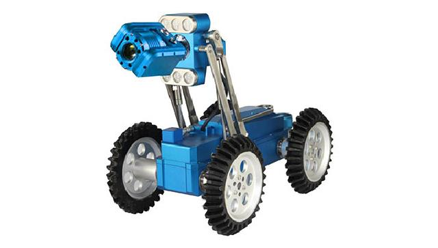
Pipeline robot | Camera | Support H.264 and MJPEG acquisition |
Zoom | 10x optical, 12x digital zoom, integrated 120x zoom | |
Material | Nickel plated, stainless steel, aluminum alloy | |
Speed | Can be steplessly adjustable, maximum speed 50CM/S | |
Protection | IP68, 10 meters underwater | |
Climbing | Climbing ability 30 degrees | |
Inclination | Inclination measurement range ±45 degrees, accuracy 0.1 degrees | |
Effective radius | Support measurement radius >300mm | |
Controller | Control function | Crawler speed, direction control, lens focus, lens rotation, light level, lens lift, start and stop control, auxiliary lighting control, video output interface |
Video output | HD 1080P | |
Input power | 220V AC, 50Hz | |
Drive | Manual / electric | |
Cable take-up | Standard length | 100 meters |
Protection level | IP63, dustproof and splashproof |